Bangalore Metro Blue Line — Route, Stations, Airport Metro & Opening Date
The Namma Metro Blue Line is Bengaluru's upcoming airport metro corridor, stretching from Central Silk Board to Kempegowda International Airport (KIA) via the Outer Ring Road and Hebbal. Spanning approximately 58 km with ~30 stations, it is being built in two phases — Phase 2A along the ORR (13 stations, late 2026 target) and Phase 2B to the airport (17 stations, June 2027 target). Updated June 2026.
Phase 2A (Silk Board–KR Puram, ORR section) targets late 2026, with depot connectivity delays potentially pushing it to 2027. Phase 2B (airport extension to KIA) is targeted for June 2027. This page will be updated as construction progresses.
Blue Line — Quick Facts
- Route: Central Silk Board ↔ Kempegowda International Airport (KIA)
- Stations: ~30 (13 Phase 2A + 17 Phase 2B) • Length: ~58 km
- Status: Under construction — not yet open
- Phase 2A (ORR, 13 stations): Target late 2026 / early 2027
- Phase 2B (Airport, 17 stations): Target June 2027
- Interchanges: Yellow Line (Silk Board), Pink Line (Nagawara)
Blue Line at a Glance
| Terminals | Central Silk Board ↔ KIAL Terminals (Airport) |
| Number of stations | ~30 (13 Phase 2A + 17 Phase 2B) |
| Length | ~58 km (19.75 km Phase 2A + ~38 km Phase 2B) |
| Status | Under construction |
| Phase 2A opening (ORR) | Target late 2026 (depot delays may push to 2027) |
| Phase 2B opening (Airport) | Target June 2027 (Hebbal–Airport section) |
| Colour code | Blue |
| Type | Fully elevated |
| Interchanges | Yellow Line at Silk Board; Pink Line at Nagawara |
| Operator | BMRCL (Namma Metro) |
All Blue Line Stations (in order)
From Central Silk Board in the south to Kempegowda International Airport in the north. All stations are elevated.
Phase 2A — Outer Ring Road Section (13 stations, target late 2026)
| # | Station | Nearby / Notes |
|---|---|---|
| 1 | Silk Board | Southern terminus. Interchange — Yellow Line. Silk Board junction, major ORR gateway. |
| 2 | HSR Layout | HSR Layout, ORR tech corridor. |
| 3 | Agara | Agara Lake area, HSR Layout / Koramangala. |
| 4 | Ibbalur | Ibbalur, Bellandur, ORR. Expected operational December 2026. |
| 5 | Bellandur | Bellandur, major IT hub on ORR. |
| 6 | Kadubeesanahalli | Kadubeesanahalli, near Embassy Tech Village. |
| 7 | Kodibisanahalli | Kodibisanahalli, ORR. |
| 8 | Marathahalli | Marathahalli Bridge — one of Bengaluru's busiest ORR junctions. |
| 9 | ISRO | Near ISRO campus, Outer Ring Road. |
| 10 | Doddanekundi | Doddanekundi, ITPL / Whitefield corridor. |
| 11 | DRDO Sports Complex | Near DRDO Sports Complex, Marathahalli area. |
| 12 | Sarasvathi Nagara | Sarasvathi Nagara (formerly Mahadevapura), east Bengaluru. |
| 13 | KR Puram | Krishnarajapura. Northern end of Phase 2A. Railway junction, east Bengaluru. |
Phase 2B — Airport Extension (17 stations, target June 2027)
| # | Station | Nearby / Notes |
|---|---|---|
| 14 | Kasturinagara | Kasturinagara, east Bengaluru. Phase 2B start. |
| 15 | Horamavu | Horamavu, north-east Bengaluru. |
| 16 | HRBR Layout | HRBR Layout, Kalyan Nagar area. |
| 17 | Kalyan Nagar | Kalyan Nagar, north Bengaluru. |
| 18 | HBR Layout | Hoysalanagara / HBR Layout. |
| 19 | Nagawara | Interchange — Pink Line. Nagawara, north Bengaluru. Connects to Pink Line terminal. |
| 20 | Veerannapalya | Veerannapalya, near Hebbal flyover. |
| 21 | Kempapura | Kempapura, Hebbal area, north Bengaluru. |
| 22 | Hebbal | Hebbal flyover junction. Blue Line turns north toward Airport Road from here. |
| 23 | Kodigehalli | Kodigehalli, NH 44 (Old Bellary Road). |
| 24 | Jakkur Cross | Jakkur Cross, Airport Road. |
| 25 | Yelahanka | Yelahanka town, Airport Road. Major satellite town north of Bengaluru. |
| 26 | Bagalur Cross | Bagalur Cross, NH 44. |
| 27 | Bettahalasuru | Bettahalasuru, near KIA. |
| 28 | Doddajala | Doddajala, airport approach zone. |
| 29 | Airport City | Airport City precinct near KIA. |
| 30 | KIAL Terminals | Northern terminus. Kempegowda International Airport. Direct access to departure & arrival terminals. |
Blue Line Opening Timeline
The Blue Line is being constructed in two phases due to the scale of the project — the ORR section and the longer airport extension.
Phase 2A — Outer Ring Road Section
13 stations: Silk Board → KR Puram • 19.75 km elevated
Targeted for late 2026. As of April 2026, trial runs were in preparation but depot link connectivity remained pending. BMRCL has cited late 2026 as the target, though some reports suggest the timeline could slip into 2027. This section will serve the dense ORR tech corridor including Bellandur, Marathahalli and ISRO.
Phase 2B — Airport Extension
17 stations: Kasturinagara → KIAL Terminals • ~38 km elevated
Targeted for June 2027. The Hebbal–Airport section specifically has been cited with a June 2027 target. Phase 2B runs north from KR Puram area through Hebbal and along Airport Road (NH 44) to Kempegowda International Airport. Construction is ongoing.
Interchanges & Connections
- Silk Board (Yellow Line) — Central Silk Board is the southern terminus of both the Blue Line and the Yellow Line. This will be a direct street-level or elevated interchange connecting the ORR corridor to Electronic City, RV Road, BTM Layout and the full Yellow Line.
- Nagawara (Pink Line) — The Blue Line Phase 2B passes through Nagawara, which is also the northern terminus of the Pink Line. This interchange will link the airport corridor directly to MG Road, Jayadeva Hospital and south Bengaluru via the Pink Line.
When the Blue Line opens, you'll be able to use the journey planner to plan multi-line routes that include the Blue Line.
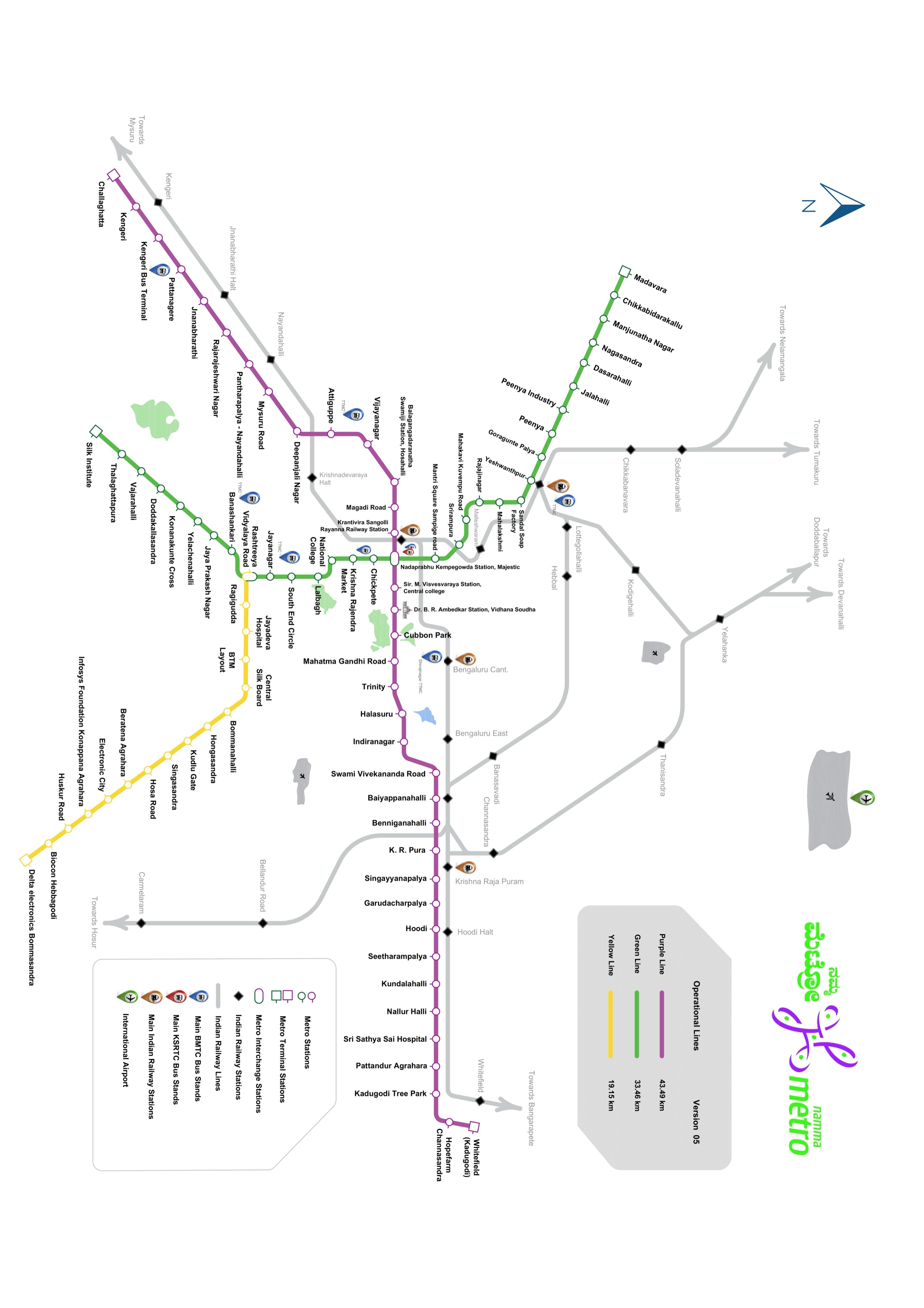
Blue Line on the Metro Map
The current network map shows the operating lines; the Blue Line corridor runs east–north along the ORR from Silk Board to the airport.
Why the Blue Line Matters
The Blue Line is arguably the most strategically important corridor in the Namma Metro Phase 2 expansion:
- Airport connectivity — Bengaluru is India's busiest airport by passenger volume. The current 40–90 minute taxi/bus ride from the city will be replaced by a reliable, affordable metro connection once Phase 2B opens in 2027.
- ORR tech corridor — Phase 2A serves the densest stretch of the Outer Ring Road — home to Bellandur, Marathahalli, Kadubeesanahalli and ISRO — where hundreds of thousands of IT workers currently face chronic traffic congestion.
- Multi-line connectivity — The Silk Board interchange with the Yellow Line and the Nagawara interchange with the Pink Line mean the Blue Line will knit together three major Phase 2 corridors, enabling seamless travel across much of the city.
- North Bengaluru growth — Yelahanka, Hebbal and the surrounding areas are among Bengaluru's fastest-growing suburbs. The Blue Line will give these areas their first metro connection.
Blue Line — Frequently Asked Questions
When will the Bangalore Metro Blue Line open?
The Blue Line opens in two phases. Phase 2A (13 stations, Silk Board to KR Puram) is targeted for late 2026, though depot connectivity delays could push it to 2027. Phase 2B (17 stations, airport extension to KIA) is targeted for June 2027. As of mid-2026, neither phase is open to passengers.
Will there be a direct metro to Bangalore Airport?
Yes — when Phase 2B opens (targeted June 2027), there will be a direct metro connection from the city to KIAL Terminals station at Kempegowda International Airport. No airport transfer will be needed. Until then, the nearest current metro station is Nagasandra on the Green Line (about 35 km away), with buses continuing to the airport.
How many stations are on the Blue Line?
The full Blue Line will have approximately 30 stations — 13 in Phase 2A (the ORR section, Silk Board to KR Puram) and 17 in Phase 2B (the airport extension, Kasturinagara to KIAL Terminals). The total length is approximately 58 km.
What is the route of the Blue Line metro?
The Blue Line runs from Central Silk Board (south Bengaluru) east along the Outer Ring Road through Bellandur, Marathahalli and ISRO to KR Puram, then continues north through Kasturinagara, Nagawara, Hebbal and Yelahanka along Airport Road to KIAL Terminals (Kempegowda International Airport). The entire line is elevated.
Which lines interchange with the Blue Line?
The Blue Line will interchange with the Yellow Line at Silk Board (both lines terminate here) and with the Pink Line at Nagawara (where the Pink Line terminates). These interchanges connect the Blue Line to Electronic City in the south and MG Road / Jayadeva Hospital in the west.
What is the nearest metro station to Bangalore Airport now?
As of mid-2026, Nagasandra on the Green Line is the closest operational metro station to Kempegowda International Airport (about 35 km away by road). Once the Blue Line Phase 2B opens in 2027, KIAL Terminals station will be directly at the airport.