Bangalore Metro Pink Line — Route, Stations, Map & Opening Date
The Namma Metro Pink Line is Bengaluru's most anticipated new metro corridor, running from Kalena Agrahara to Nagawara via Bannerghatta Road and MG Road. Spanning 21.26 km with 18 stations (6 elevated, 12 underground), it is currently under construction and opening in phases in 2026. Trial runs are underway. Updated June 2026.
The elevated section (6 stations) is expected to open in 2026; the full line including underground stations is targeted for December 2026. This page will be updated when the line opens.
Pink Line — Quick Facts
- Route: Kalena Agrahara ↔ Nagawara (via Bannerghatta Road & MG Road)
- Stations: 18 (6 elevated + 12 underground) • Length: 21.26 km
- Status: Under construction — opens in phases in 2026
- Phase 1 (elevated, 6 stations): Expected 2026
- Phase 2 (full line): Expected December 2026
- Interchanges: Yellow Line (Jayadeva Hospital), Purple Line (MG Road)
Pink Line at a Glance
| Terminals | Kalena Agrahara ↔ Nagawara |
| Number of stations | 18 (6 elevated + 12 underground) |
| Length | 21.26 km |
| Status | Under construction — trial runs underway |
| Phase 1 opening (elevated) | Expected 2026 (6 stations: Kalena Agrahara–Tavarekere) |
| Phase 2 opening (full line) | Expected December 2026 (12 underground stations added) |
| Colour code | Pink |
| Interchanges | Yellow Line at Jayadeva Hospital; Purple Line at MG Road |
| Operator | BMRCL (Namma Metro) |
All 18 Pink Line Stations (in order)
From Kalena Agrahara in the south to Nagawara in the north. Stations marked 🔵 are underground; others are elevated.
Phase 1 — Elevated Section (6 stations, opening 2026)
| # | Station | Nearby / Notes |
|---|---|---|
| 1 | Kalena Agrahara | Southern terminus. Elevated. Bannerghatta Road, south Bengaluru. |
| 2 | Hulimavu | Elevated. Hulimavu, Bannerghatta Road. |
| 3 | IIMB | Elevated. Indian Institute of Management Bangalore. |
| 4 | JP Nagar 4th Phase | Elevated. JP Nagar residential area. |
| 5 | Jayadeva Hospital | Elevated. Interchange — Yellow Line. Sri Jayadeva Institute of Cardiovascular Sciences. |
| 6 | Tavarekere | Elevated. Northern end of Phase 1. Bannerghatta Road / Hosur Road junction. |
Phase 2 — Underground Section (12 stations, opening December 2026)
| # | Station | Nearby / Notes |
|---|---|---|
| 7 | 🔵 Dairy Circle | Underground. Dairy Circle Junction, Hosur Road. |
| 8 | 🔵 Lakkasandra | Underground. Lakkasandra, inner south Bengaluru. |
| 9 | 🔵 Langford Town | Underground. Langford Town / Langford Road area. |
| 10 | 🔵 National Military School | Underground. Near National Military School, central Bengaluru. |
| 11 | 🔵 MG Road | Underground. Interchange — Purple Line. Mahatma Gandhi Road, central Bengaluru. |
| 12 | 🔵 Shivaji Nagar | Underground. Shivaji Nagar bus terminal area. |
| 13 | 🔵 Cantonment | Underground. Near Cantonment Railway Station, Bengaluru Cantonment. |
| 14 | 🔵 Pottery Town | Underground. Pottery Town / Frazer Town area. |
| 15 | 🔵 Tannery Road | Underground. Tannery Road, north Bengaluru. |
| 16 | 🔵 Venkateshpura | Underground. Venkateshpura area. |
| 17 | 🔵 Kadugundanahalli | Underground. Kadugundanahalli, north Bengaluru. |
| 18 | 🔵 Nagawara | Underground. Northern terminus. Nagawara, Outer Ring Road. |
Pink Line Opening Timeline
The Pink Line is being built in two phases due to the complexity of the underground tunnelling work through central Bengaluru.
Phase 1 — Elevated Section
6 stations: Kalena Agrahara → Tavarekere • 7.5 km elevated
Expected to open in 2026. Trial runs on this section are underway. CMRS (Commissioner of Metro Railway Safety) clearance is the final step before passenger operations begin.
Phase 2 — Underground Section
12 stations: Dairy Circle → Nagawara • 13.76 km underground
Targeted for December 2026. Tunnelling is complete; station finishing, track work and systems installation are in progress. The driverless train system is being deployed — 23 BEML-built driverless trains are planned for the full corridor.
Interchanges & Connections
- Jayadeva Hospital (Yellow Line) — An elevated interchange between the Pink and Yellow lines. From here you can reach RV Road, Electronic City, BTM Layout, Central Silk Board and the rest of the Yellow Line corridor.
- MG Road (Purple Line) — An underground interchange connecting the Pink Line with the existing Purple Line (East-West Corridor). From MG Road you can travel to Majestic (Nadaprabhu Kempegowda Station), Baiyyappanahalli, Whitefield and all Purple Line stations.
Once the Pink Line opens, you can use the journey planner to plan routes that use the Pink Line, including fare and travel time estimates.
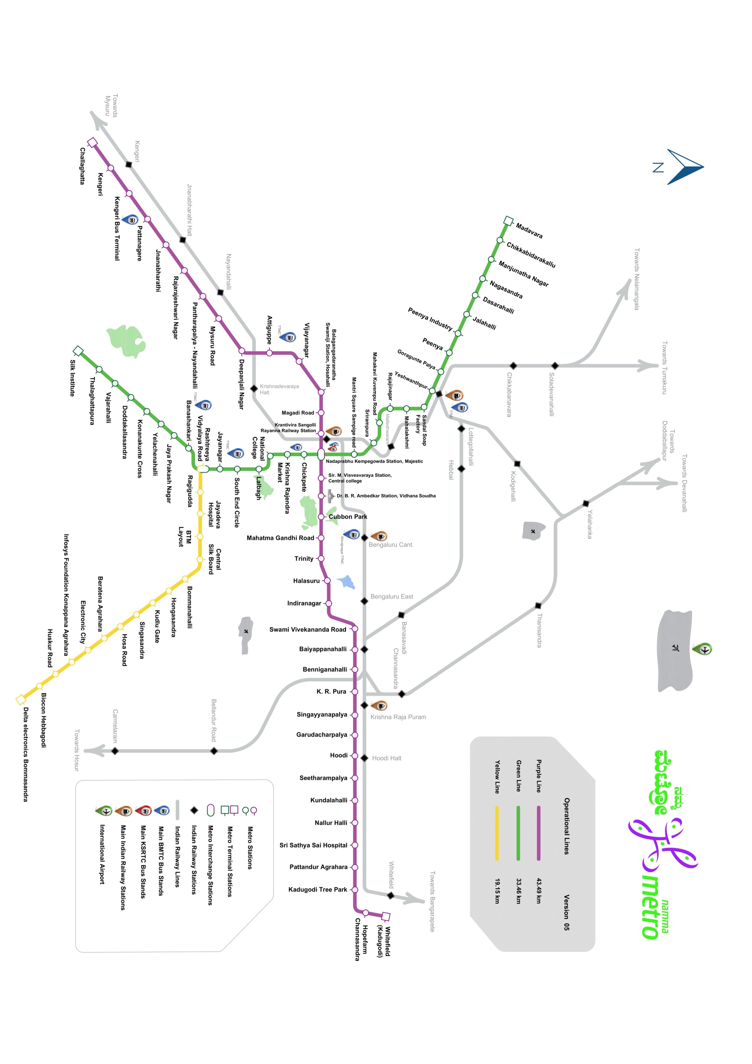
Pink Line on the Metro Map
See where the Pink Line corridor fits in the full Namma Metro network.
Why the Pink Line Matters
The Pink Line (Reach 1 of Phase 2A) is one of the most significant additions to the Namma Metro network. Here's what it will change:
- South Bengaluru connectivity — Areas like Hulimavu, JP Nagar and IIMB have no metro connection today; the Pink Line will be their first rail link.
- City centre access — The underground section passes through Dairy Circle, Langford Town and MG Road, connecting inner south Bengaluru to the CBD without a road transfer.
- Driverless technology — The Pink Line will be Bengaluru's first driverless metro line, using a Communications-Based Train Control (CBTC) system for higher frequency and reliability.
- Reduced Bengaluru south traffic — Bannerghatta Road and Hosur Road corridors see some of the worst congestion in the city; the Pink Line offers a direct alternative.
Pink Line — Frequently Asked Questions
When will the Bangalore Metro Pink Line open?
The Pink Line is opening in two phases. The elevated section (6 stations, Kalena Agrahara to Tavarekere) is expected to open in 2026, with trial runs already underway. The underground section (12 stations, Dairy Circle to Nagawara) is targeted for December 2026. As of mid-2026 the line has not yet opened to passengers.
How many stations are on the Pink Line?
There are 18 stations — 6 elevated (Kalena Agrahara to Tavarekere on Bannerghatta Road) and 12 underground (Dairy Circle to Nagawara through central Bengaluru). Total length is 21.26 km.
What is the route of the Pink Line?
The Pink Line runs from Kalena Agrahara (south Bengaluru, Bannerghatta Road) to Nagawara (north Bengaluru, Outer Ring Road), passing through Hulimavu, IIMB, JP Nagar, Jayadeva Hospital, Tavarekere, Dairy Circle, Langford Town, MG Road, Shivaji Nagar, Cantonment and Pottery Town.
Which metro lines interchange with the Pink Line?
The Pink Line will interchange with the Yellow Line at Jayadeva Hospital station and with the Purple Line at MG Road station. These are the two key transfer points connecting the Pink Line to the rest of the Namma Metro network.
Does the Pink Line go to MG Road?
Yes — the Pink Line has a dedicated underground station at MG Road (station 11), which will be an interchange with the existing MG Road Purple Line station.
What is the southern terminus of the Pink Line?
The southern terminus is Kalena Agrahara, an elevated station on Bannerghatta Road in south Bengaluru (near Gottigere).