Search for a station below, or tap any station on the interactive map to see exits, parking and nearby places.
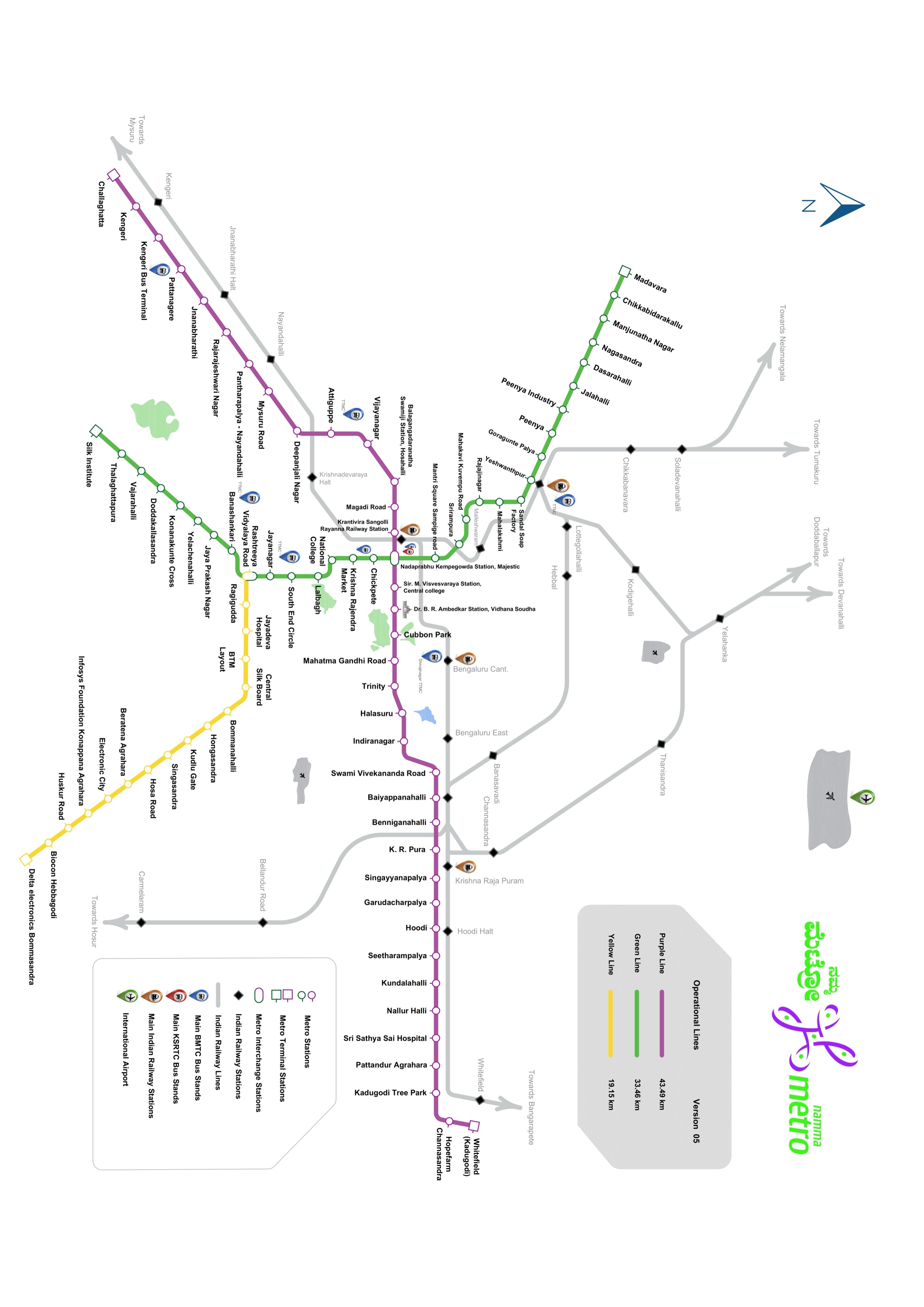
This Bangalore Metro map (Namma Metro route map) shows the complete operational network for 2026 — all 86 stations across 3 lines (Purple, Green and Yellow), with interchanges at Majestic (Nadaprabhu Kempegowda) and RV Road. Tap any station on the interactive map above to see its facilities, exits and nearby places, or browse the full line details and station list below. The Yellow Line to Electronic City opened in August 2025.
Coming to the Network — Pink Line, August 2026
The Pink Line (21.26 km, 18 stations, Kalena Agrahara to Nagawara) is targeting an August 2026 opening for its elevated Phase 1 section (6 stations: Kalena Agrahara to Tavarekere). The underground Phase 2 section (12 stations) follows in December 2026. Once fully open the network will expand to 104 stations across 4 lines. Interchange with Yellow Line at Jayadeva Hospital; with Purple Line at MG Road (underground section). Map will be updated when the line opens.
Purple Line (East-West Corridor) — 38 stations from Whitefield in the east to Challaghatta in the west, running through MG Road, Cubbon Park, and the central interchange at Nadaprabhu Kempegowda Station (Majestic). Key stations include Indiranagar, Baiyyappanahalli, KSR Railway Station, Vijayanagar, and Kengeri.
Green Line (North-South Corridor) — 32 stations from Madavara in the north to Silk Institute in the south, passing through Nagasandra, Yeshwanthpur, Rajajinagar, and Nadaprabhu Kempegowda Station before continuing south through Lalbagh, Jayanagar, and Banashankari.
Yellow Line (RV Road–Bommasandra) — 16 stations inaugurated in August 2025, connecting Rashtreeya Vidyalaya Road (interchange with Green Line) to Delta Electronics Bommasandra via BTM Layout, Central Silk Board, Hongasandra, Kudlu Gate, Singasandra, Hosa Road, and Electronic City. The line serves the IT corridor along Hosur Road and significantly reduces commute times to Electronic City.
| Line | Route (terminals) | Length | Stations |
|---|---|---|---|
| Purple | Whitefield ↔ Challaghatta | 43.5 km | 38 |
| Green | Madavara ↔ Silk Institute | 33.5 km | 32 |
| Yellow | RV Road ↔ Bommasandra | 19.15 km | 16 |
| Pink (Opening 2026) | Kalena Agrahara ↔ Nagawara | 21.26 km | 18 |
Future phases of Namma Metro will add more lines to the Bangalore metro map:
These lines are not yet operational and are not shown on the current map above. Map will be updated when each line opens.
Tap or click any station circle on the map to open that station's detail page — showing exits, parking, nearby landmarks, feeder buses, and connecting routes. To plan a journey between two stations, use the Journey Planner on the homepage, or check the Bangalore Metro timings for first and last train times on each line.
Station codes (three-letter codes shown at each station) can be used when buying tokens at BMRCL ticket machines. The map is updated to reflect the latest operational network as of 2026.
Namma Metro has 86 stations across three lines: the Purple Line (38 stations, Whitefield to Challaghatta), the Green Line (32 stations, Madavara to Silk Institute), and the Yellow Line (16 stations, RV Road to Bommasandra via Electronic City).
The Yellow Line connects Electronic City to the network, running from Rashtreeya Vidyalaya Road (interchange with the Green Line) to Bommasandra, through Electronic City Phase 1 and 2. From the Purple Line, change at Majestic to the Green Line, then at RV Road to the Yellow Line.
There are two interchanges: Nadaprabhu Kempegowda Station (Majestic), where the Purple and Green lines meet, and Rashtreeya Vidyalaya Road, where the Green and Yellow lines meet. Allow about 5 minutes to change platforms.
Trains run from about 5:00 AM to 11:05 PM on weekdays and Saturdays, and from 7:00 AM on Sundays, every 7–8 minutes at peak. See the full Bangalore Metro timings.
Fares are distance-based from ₹10 to ₹90 (revised February 2025), with a discount on Smart Card and QR tickets. Check the exact fare with the fare chart or the fare calculator.
The Pink Line Phase 1 (6 elevated stations, Kalena Agrahara to Tavarekere along Bannerghatta Road) is targeting August 2026 for passenger operations — RDSO speed trials were cleared in June 2026 and CMRS inspection is the final step. The underground Phase 2 (12 stations, Dairy Circle to Nagawara) is expected in December 2026. The full Pink Line (21.26 km, 18 stations) will connect south Bengaluru to the city centre.
The Pink Line will have 18 stations in total — 6 elevated stations (Kalena Agrahara, Hulimavu, IIMB, JP Nagar 4th Phase, Jayadeva Hospital, Tavarekere) and 12 underground stations (Dairy Circle through MG Road to Nagawara). It will interchange with the Yellow Line at Jayadeva Hospital and with the Purple Line at MG Road (underground section).
Whitefield · Hopefarm Channasandra · Kadugodi Tree Park · Pattanduru Agrahara · Sri Sathya Sai Hospital · Nallurhalli · Kundalahalli · Vardapura · Seetharamapalya · Hoodi · Garudacharpalya · Singayyanapalya · Krishnaraja Puram · Benniganahalli · Baiyyappanahalli · Swami Vivekananda Road · Indiranagar · Halasuru · Trinity · MG Road · Cubbon Park · Dr. BR Ambedkar Station · Sir M Visvesvaraya Station · Nadaprabhu Kempegowda Station · KSR Railway Station · Magadi Road · Hosahalli · Vijayanagar · Attiguppe · Deepanjali Nagar · Mysore Road · Pantharapalya (Nayandahalli) · Rajarajeshwari Nagar · Jnanabharathi · Pattanagere · Kengeri Bus Terminal · Kengeri · Challghatta
Madavara · Chikkabidarakallu · Manjunathnagar · Nagasandra · Dasarahalli · Jalahalli · Peenya Industry · Peenya · Goraguntepalya · Yeshwanthpur · Sandal Soap Factory · Mahalakshmi · Rajajinagar · Kuvempu Road · Srirampura · Mantri Square Sampige Road · Nadaprabhu Kempegowda Station · Chickpete · Krishna Rajendra Market · National College · Lalbagh · South End Circle · Jayanagar · Rashtreeya Vidyalaya Road · Banashankari · Jaya Prakash Nagar · Yelachenahalli · Konanakunte Cross · Doddakallasandra · Vajarahalli · Thalaghattapura · Silk Institute
Full Yellow Line guide — route, timings, interchanges & Electronic City stations →
Rashtreeya Vidyalaya Road · Ragigudda · Jayadeva Hospital · BTM Layout · Central Silk Board · Bommanahalli · Hongasandra · Kudlu Gate · Singasandra · Hosa Road · Beratena Agrahara · Electronic City · Infosys Foundation Konappana Agrahara · Huskur Road · Biocon Hebbagodi · Delta Electronics Bommasandra